
A photographer's loop drive around Watauga Lake
A specific scenic loop drive for landscape photographers around Watauga Lake, with timing for golden hour, blue hour, and three pullouts worth waiting for.
By Bill · May 14, 2026
On this page
I have driven this loop maybe forty times over the four years Karen and I have been here. It started as a way to show visiting family the lake from every angle in a single day, and it turned into the route I take when a guest tells me they are a serious photographer and they have one full day to shoot.
There is a separate general article on photographing Watauga Lake that covers each location in more detail with gear notes. This piece is the route, in order, with the timing. If you read both and have the day, this is the day to plan.
A note on the assumption: I am writing this as a self-driving loop for a photographer who wants to be in position for sunrise, golden hour, mid-day forest detail work, late afternoon water shots, blue hour at the dam, and a possible sunset coda. The loop is built around the light. If you want a more relaxed scenic drive without the dawn alarm, skip the sunrise stop and start with the second.
The route in a sentence
From the south shore, east on US-321 to the dam observation point for sunrise, north across the dam and up to Rat Branch for mid-morning, west across the north shore on TN-67 to Butler for late morning, south through Hampton for lunch, back east through Watauga Point and Shook Branch for afternoon, ending at the dam observation point again for blue hour. Total mileage is about 55 to 65 depending on which spurs you take.
Stop 1: dam observation point, sunrise
Be in the parking area at the dam observation point thirty minutes before official sunrise. There is a railing-fronted overlook that gives you a panoramic view back up the length of the lake to the west. The lake faces you. The sun comes up behind you over the ridge. The first light hits the upper slopes across the water before it hits the water itself, which means the mountains are lit before the lake is, and the lake is still dark and reflective with the sky in it.
This is the shot. A long exposure as the upper slopes glow and the water mirrors a sky that is just starting to pink. The water on most mornings from late September through mid-November carries patches of mist, and the mist catches the first light in a way that is the headline image of the loop.
Bring a tripod, set up at the railing, and shoot a sequence as the light comes up. The light changes every two minutes for about fifteen minutes. Bracket exposures because the dynamic range is real. Polarizing filter to kill any glare. ISO low. Aperture around f/11.
Stay until thirty minutes after sunrise. By then the sun is well above the ridge and the magic light is over. The lake goes flat blue. Move on.
Stop 2: across the dam, AT crossing
Drive the short distance to the dam parking area and walk out onto the top of the dam. The Appalachian Trail crosses the top of the 331-foot earthen wall, which is one of the most unusual photo subjects in the region. The lake is on one side, a thousand-foot drop into the river gorge on the other.
At this hour, around an hour and a half after sunrise, the side light is good. The shadow of your tripod will be long across the path. Wide-angle work, 16-35 or 14-24. The composition that works best is the path running away from you with the lake on the left and the sky open above. If you wait, an AT thru-hiker often comes through. Ask permission for a person in the shot. Most say yes.
Allow forty-five minutes for the dam crossing if you want to walk to the far end and back. It is roughly a quarter mile across.
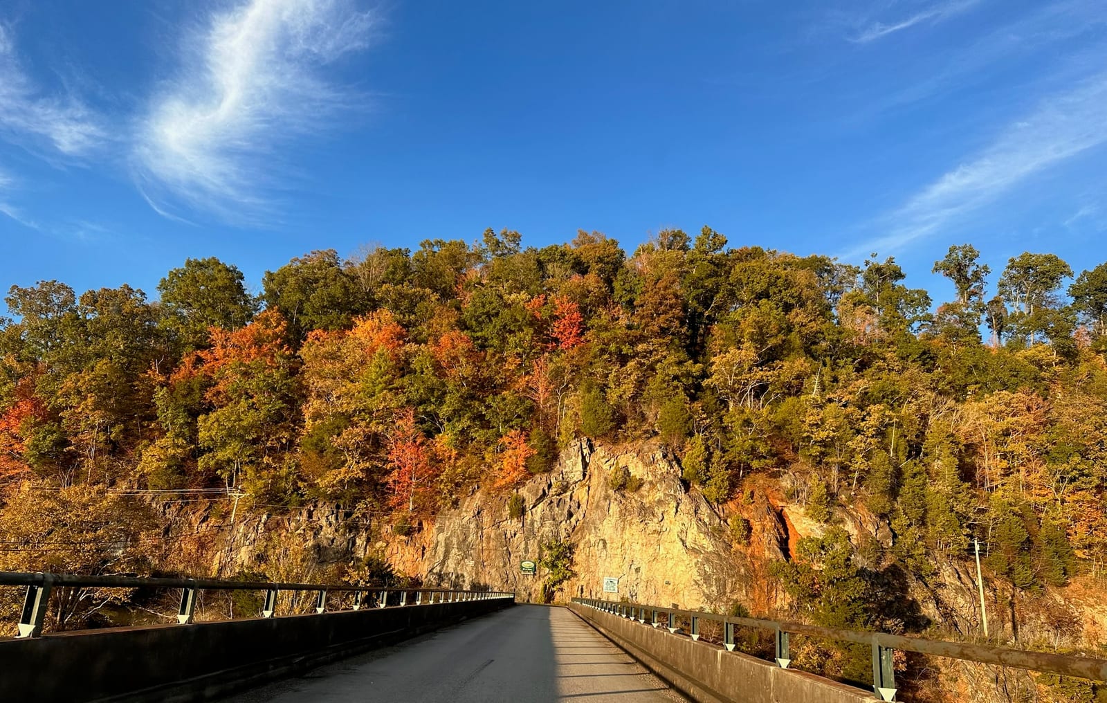
Stop 3: north shore drive, TN-67 west
From the dam, get back on the road and take TN-67 north and then west. This road runs along the north side of the lake for several miles, with a string of pullouts that offer different angles. Two are worth stopping at.
The first is about two miles north of the dam, an unmarked gravel pullout on the south side of the road, with an opening through the trees that reveals the lake stretching east. The light at mid-morning, around three hours after sunrise, comes from your right and sidelights the surface of the water. Less dramatic than sunrise but very clean. A polarizer here transforms the water from a glare-flat blue to a saturated deep teal that nobody at the railing in the morning gets to see.
The second is a couple of miles further west, where TN-67 climbs up the ridge and opens to a broader vista. Look for a wide shoulder on the lake side of the road. The view is more elevated, more of the lake visible in a single frame. Bring the wide angle.
Stop 4: Rat Branch and the eagle bench
Continue west on TN-67 toward Butler and turn into the Rat Branch Boat Launch. There is a small parking area, a launch, and a bench at the water’s edge. This is one of the public viewpoints where local birders have watched eagles work the lake for years.
By mid-morning the eagles are usually active. Set up a long lens, 400mm minimum, on a tripod or monopod, and watch the open water and the tall snags along the shoreline. The eagles fish the surface, and the photographs you can get of an eagle dropping toward the water with the lake behind it are some of the most rewarding work the lake offers.
This is also a good landscape stop. The view east from Rat Branch back toward the dam is roughly the reverse of the sunrise view, with the dam now in the distance and the lake stretching toward you. At mid-morning the light is even across the water. A wider lens captures the full sweep.
Allow an hour here. Possibly two if the eagles are active.
Stop 5: Butler and the road into town
Drive into Butler, the small town at the west end of the lake. Butler itself does not photograph dramatically, but the road in carries several roadside-pullout views of the lake’s western arm, with farmland in the foreground. This is the agricultural-Appalachian aesthetic, hay fields rolling down to the water, barns, distant peaks. Different from the forest-and-water aesthetic of the east end. Worth a few frames if you have the time.
Old Butler, the original town that the lake submerged in 1948, has a museum that is worth a quick stop for context on what is under the water. Not a photo destination per se. Useful for understanding what you are looking at when you stand on the shore.
Stop 6: lunch in Hampton
By now it is around noon. Mid-day light is the worst light of the day for landscape work, so this is the time to eat and reset. Drive south from Butler on TN-67 (which becomes US-321) and stop in Hampton.
The Watauga Lake Mercantile makes a tomato-and-basil sandwich that is better than expected. There are picnic tables outside if it is warm enough to eat in the sun. Captain’s Table at Watauga Lakeshore Resort is on the water and has a deck you can pull a boat up to, if it is open. Check ahead because operating status has been variable since a 2023 fire.
Spend an hour. Charge your camera batteries in the car or at the restaurant. Look through what you have shot so far on the screen and decide if any stop needs a return visit. Drink water. The afternoon is the longest stretch of the day.
Stop 7: Watauga Point Recreation Area
After lunch, head east on US-321 a few minutes and pull into Watauga Point Recreation Area. The south shore has a series of picnic tables and shoreline access points. The mid-afternoon light on a calm day reflects the sky into the lake and the surrounding forest comes alive with green or autumn color, depending on season.
This is also a place to shoot forest detail. Wildflowers in spring, ferns and mosses in summer, leaf litter in fall, bare branches in winter. A macro lens or a 70-200 used at close-focus gives you photographs at a different scale than the big landscapes.
If you are tired of landscape work, this is a good break. Sit on a picnic table. Eat the snack you brought. Watch the water.
Stop 8: Shook Branch and the AT along the lake
A few minutes further east on US-321 is Shook Branch Recreation Area, which is the most-used trailhead for the section of the Appalachian Trail that runs along the south shore of the lake. Park, walk west on the AT for fifteen minutes, and you are on a flat shaded path with the water visible through the trees on your right.
This stretch is the photographic complement to the dam crossing. The dam shot is dramatic and monumental. The AT along the lake is intimate, quiet, small detail work. Trillium in April, mountain laurel in June, oak and maple in October, snow in January. Get low. Use a tripod. Slow down.
The first cove out has a small clearing on the lake’s edge that catches afternoon light well. A photograph of the AT blazes on a tree trunk with the lake glittering through the rhododendron behind is the kind of frame that feels like the trail.
Allow ninety minutes for the round trip walk and shooting.
Stop 9: back to the dam, late afternoon
Drive back east to the dam observation point. By now it is late afternoon, an hour or so before sunset. The light is now coming from your right, sidelighting the dam itself and warming the stone face. The shot here is the dam from the observation overlook, with the late sun raking across the lower face and the lake catching the warm light.
If you walked the dam in the morning, walk it again now. The light is completely different. The shadow patterns are different. The same composition photographed at first light and last light makes a good diptych and shows the day better than any single frame.
Stop 10: blue hour, the final image
After the sun drops behind the ridge, do not pack up. Blue hour, the twenty to thirty minutes after sunset when the sky goes deep blue and the world is in even ambient light, is when the lake gives you one more photograph. The water turns a deep saturated color. The mountains across become silhouettes. The sky above holds light for longer than you expect.
A long exposure of the lake at blue hour, with the sky above still glowing and the mountains as dark cutouts, is the closing image of the loop. Tripod essential. Cable release or two-second timer. ISO low, aperture around f/8 to f/11, exposure as long as fifteen or twenty seconds depending on how dark it has gotten.
Stay until you cannot see the viewfinder. Pack up in the dark. Drive carefully back to wherever you are staying. The roads have deer and the deer come out at this hour.
Variations
The loop above is the one-day full intensive. A few variations for different situations.
The half-day version, sunrise to mid-morning. Stop 1 (dam at sunrise), Stop 2 (AT crossing), Stop 3 (north shore pullouts), Stop 4 (Rat Branch). Lunch in Hampton. Drive home. This is the version you do if you only have one morning to shoot and want the best three hours of light.
The half-day version, mid-afternoon to dusk. Lunch in Hampton, then Stop 7 (Watauga Point), Stop 8 (Shook Branch and the AT), Stop 9 (dam late afternoon), Stop 10 (dam blue hour). Same drive but in reverse and built around the evening light instead of the morning.
The fall foliage variation. Around October 15 to 25, when peak color hits the lake, the loop is more rewarding if you add a detour up Carvers Gap on the way back from Rat Branch. Drive south on TN-143 from Roan Mountain, climb to 5,512 feet, photograph the grass balds from the parking lot or hike up to Round Bald. This adds about three hours to the day. Skip the afternoon AT walk to make room. The Carvers Gap detour in fall is one of the best landscape photography hours in the southeast and is worth rearranging the day for.
The winter variation. After a snow, the loop transforms. The dam observation point in fresh snow is striking. The AT along the lake under snow is quiet beyond description. Be cautious. Roads can ice. Allow more time. Skip the Carvers Gap detour unless conditions are clearly safe.
The wildlife-focused variation. Spend less time on landscape stops and more time at Rat Branch and on the AT for bird photography. The eagles are active morning and late afternoon. Trade landscape ambition for patience. Pick one stationary spot and stay there for two or three hours. Most of my best bird images come from that approach.
A few small things that make the day better
Charge two batteries the night before. The cold lakeside air at sunrise eats battery life faster than you expect. A backup is not optional.
Bring a thermos of coffee for the sunrise stop. There is no coffee shop open at 5:45 AM near the dam.
Pack a real lunch in addition to or instead of the Hampton stop, in case timing makes the restaurant tight. Sandwiches, an apple, water. Eat at a pullout.
Wear layers. Lake mornings in May are forty-five degrees. Lake afternoons in May are seventy-five. You will be uncomfortable in one or the other if you only dress for one.
Bring a chair. A small folding camp chair changes a landscape photographer’s day. Most of my best images come from sitting in one spot for ninety minutes and waiting. The chair is the difference between leaving after twenty minutes and staying for the shot.
Charge a phone with the camera and the route loaded offline. Cell coverage is patchy on the north shore. A printed map or downloaded route is worth ten minutes of fiddling at home.
Where the loop starts and where it ends
If you are staying at our townhouse on the hilltop above Butler, the loop starts at your back door. Drive east on US-321 from the property and you are at the dam in twenty minutes. End the day back at the property, on the deck, with the camera packed and a glass of wine. The deck is also one of the best stationary landscape positions on the lake. I have written before that most of my best lake images come from coffee, a chair, a tripod, and patience on that porch. The loop above is the variation that takes you out into the larger lake instead of staying at home.
For the gear-by-location breakdown, see the general photography article. For the fall color version of this drive at peak season, see the fall foliage piece. For information on the property you might be starting from, see the property page. For booking, see the booking page.
The lake gives you a different photograph at every hour. The loop is just the structure that lets you collect one at each. The work is showing up before light and staying until after dark. The rest is the lake doing what the lake does.
Want to stay at the lake?
Our modern two-bedroom townhouse has sweeping lake and mountain views, a jet tub, and a gas fire pit on the back porch.
Common questions
How long does the loop take?
Is it drivable in winter?
Do I need a 4WD vehicle?
Where should I start the loop?
Is this the same as your general photographing Watauga Lake article?
More like this
Keep reading
A photographer's guide to Watauga Lake and the high country around it
Real photo notes on the best spots, best light, and gear choices for shooting Watauga Lake, Carvers
Fall foliage at Watauga Lake — when, where, and what nobody tells you
When fall color peaks at Watauga Lake, which drives and trails are the best for it, and the timing t
Spring at Watauga Lake — a month-by-month walk-through
What spring is like at Watauga Lake from March through May — wildflowers, water temperature, the fis
The Appalachian Trail at Watauga Lake
The AT crosses on top of Watauga Dam — a 15-minute drive from the door, with one of the most photographed views on the entire 2,200-mile trail.
Cherokee National Forest from Watauga Lake
Watauga Lake sits inside the Cherokee National Forest, which is most of why the shoreline is undeveloped and the water is so clear.